Home News & updates Article Aeropath’s Flight Advisor keeping pilots safe in uncontrolled airspace
Aeropath’s Aeronautical Information Management (AIM) team has collaborated with the Royal New Zealand Air Force to develop Flight Advisor – a web-based mapping tool two years in the making, to enhance safety for pilots flying at low level in outside of controlled airspace.

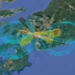
Used by RNZAF pilots as well as civilian operators across New Zealand, Flight Advisor identifies obstacles and potential hazards at low level (under 1,000 ft) which could pose risks to pilots. The tool is already proving to be invaluable to keep pilots safe in an airspace outside the boundaries of air traffic control – and accolades are flying in.
Matt Day, Josh Flynn and Jason Russell from Aeropath’s AIM team have been recognised in the New Zealand Defence Force Safety Awards 2022 for their development of Flight Advisor, alongside Matt’s brother, Flight Lieutenant Andrew Day who led the project for the RNZAF.
Here’s what Matt had to say about the project:
“This started off as an idea between my brother Andrew and I over a couple of drinks one Christmas. The question was, what could we do to address the problem of better informing low level operators of hazards (wires, towers and the like) and also about each other to better avoid the chance for a collision?
Andrew is a military pilot with a background in risk analysis and investigations. I have a background in software and manage the national Aeronautical Information Service. We thought we had an answer, and that idea became Flight Advisor. Fast forward two years and I’m really pleased to see Flight Advisor has hundreds of users, has this recognition and most importantly is delivering safety benefits for aviators across New Zealand.”
The Royal New Zealand Air Force (RNZAF) approached Aeropath in 2021 when they were seeking to improve their Low Level Flight Advisory process to enhance the safety of their aircrews.
Pilots flying at low level (below 1000’ AGL) outside controlled airspace operate in a complex environment and face multiple hazards. Helicopter logging operations with suspended cables, airborne crop spraying for agriculture, commercial and recreational RPAS operations, military training flights, and uncharted obstacles including towers, wind turbines, and wires strung across valleys, all mix in a potentially hazardous, high risk aviation environment that lies beyond the boundaries of air traffic control.
RNZAF’s existing process was largely based on distributing their low level flight intentions to local operators who subscribed to receive email notification of these operations. The RNZAF, having noted Aeropath’s spatial data management and visualisation capabilities, wanted to improve their notification process, reach a broader community of affected users, and improve the collection and processing of any uncharted hazards reported by their crews. Above all, RNZAF’s goal was to keep their aircrew safe from harm – hazards affecting low level operations are the source of many incidents.
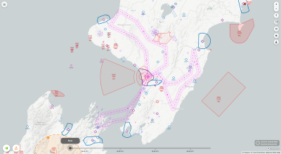
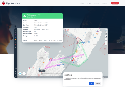
Flight Advisor vastly improves situational awareness for operators planning low level flights outside of controlled airspace.
Users can create a flight advisory in the app, drawing their planned area of operations or intended flight path on a dynamic map accessible via a computer web browser, tablet or smartphone. Other pilots using Flight Advisor can immediately see where intended flights may overlap and are therefore aware of who else might be operating in their area. Affected users can receive an email or text notification if a new flight is planned that overlaps with a previously planned flight.
Users can also easily report any uncharted hazards (wires, towers, antennas etc) they encounter. Obstacles below a certain height outside controlled airspace might not meet the historical requirements for notification and publication (on charts), making it difficult to gain updates on when new hazards affecting low level operations are erected outside of controlled airspace.
Flight Advisor enables users to drop a geolocation pin on a web map, to update the map with the hazard so all pilots are made aware; the hazard is marked as “user-reported” until verified by Aeropath’s AIM team.