


In this article, Airways International’s Head of Aeropath, Trent Clarke, shares insights around the uptake of PreFlight since its launch in 2022.
The journey from paper-based to web-based aeronautical data has been a significant transformation for Aeropath – resulting in the development of the PreFlight one-stop aviation weather and aeronautical information tool for New Zealand pilots.
This online platform, launched in September 2022 is just one outcome of the transition from paper-based outputs to digital data systems for our Aeropath team, who have global expertise in aeronautical information management and solutions.
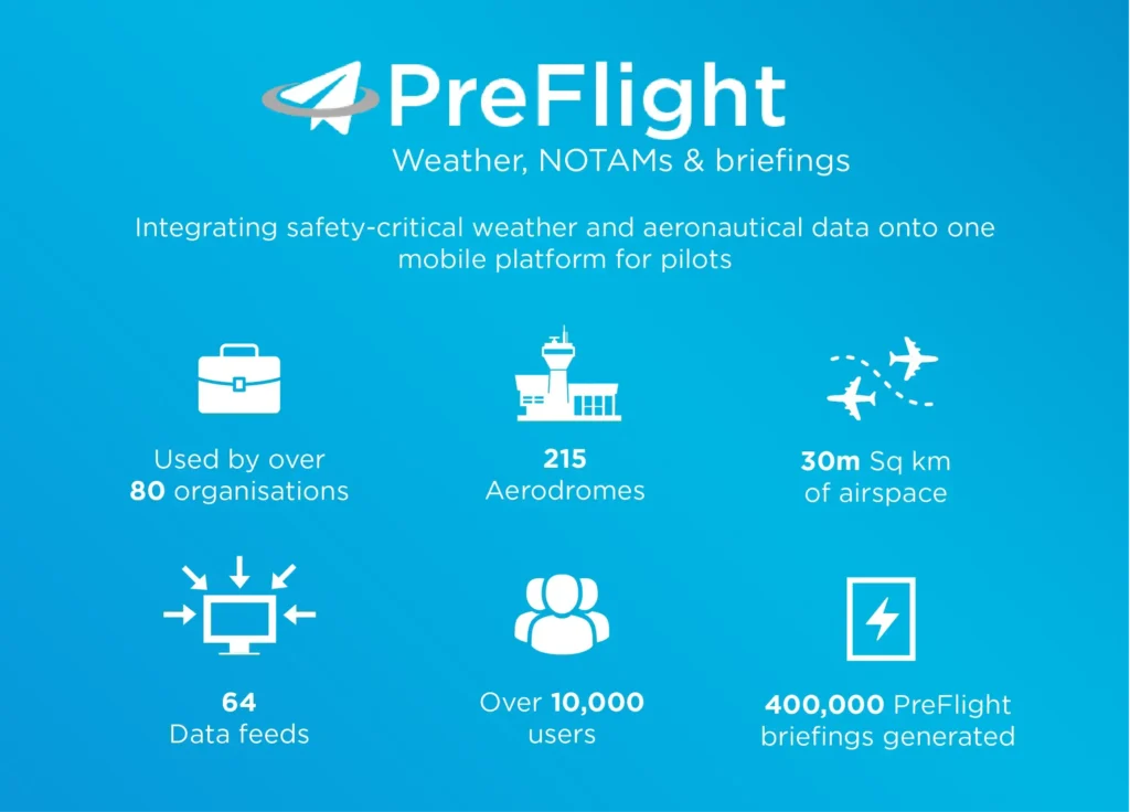
In collaboration with the New Zealand MetService, Aeropath integrated safety-critical weather and aeronautical data into a single, intuitive, graphical briefing site for New Zealand pilots – and now, 18 months on from its launch there’s over 10,000 users.
Why was it needed?
Aviators previously needed to visit two different websites to gain comprehensive pre-flight information – one hosted by Airways and the other by MetService. This was inefficient for pilots, who wanted to access all relevant pre-flight information in one place as they undertook their critical flight planning prior to take-off.
Aeropath and MetService listened to this feedback, and joined forces to develop a one-stop solution. The integration of the two sites into one modern, interactive web-based platform designed for desktop and mobile devices had been a long-standing goal – now made possible following the data modernisation journeys of both organisations.
Aeropath’s journey from paper-based to digital data
Aeropath and MetService have been on similar paths over the past decade to transition from largely manual processes and paper-based outputs to digital data systems. Aeropath’s focus has been on migrating its legacy Aeronautical Information Service (AIS) and its core products of paper charts and flight manuals, to the data-centric world of Aeronautical Information Management (AIM).
While the flight manuals and charts are still produced in hard copy, they are now also available in digital format – with the majority of Aeropath’s AIM services now run from the data platform. New GIS systems, with their emphasis on the visualisation of spatial data, have streamlined the production of the most complex navigation charts, and the organisation is diversifying its aeronautical products and services through its digital information business.
How is PreFlight supporting pilots?
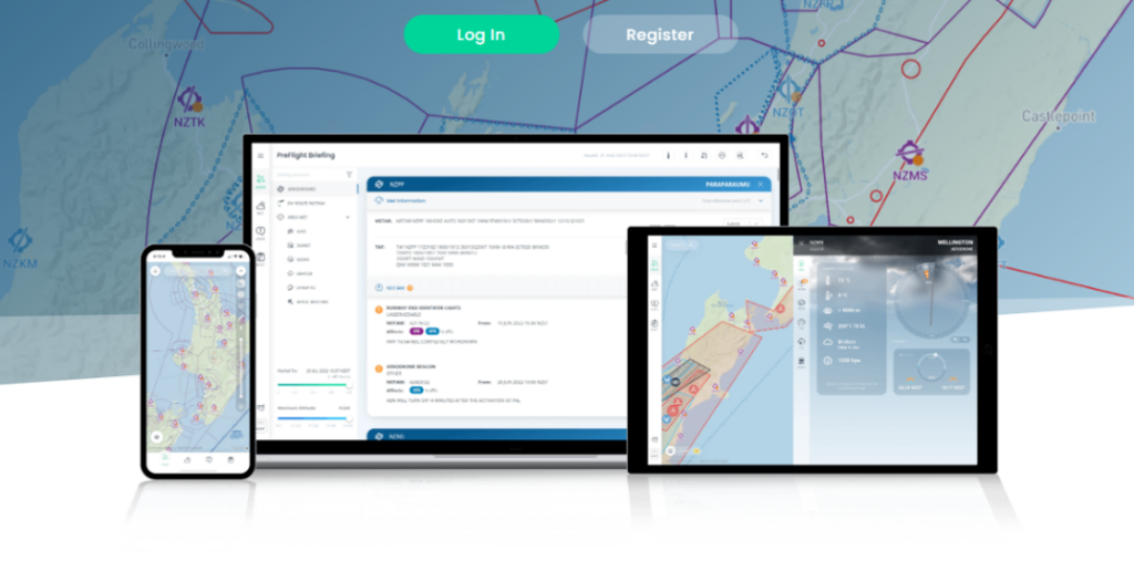
PreFlight represents the next generation of AIM data visualisation and user interaction. The free version encompasses basic maps, aerodrome data, airspace, weather charts, and standard pre-flight briefings. Aviators subscribing to the premium service gain access to advanced briefing features, advanced rain radar and cloud imagery, enhanced aerodrome information including decoded TAF and METAR, aerodrome charts and webcams.
Premium users can also access interactive map overlays featuring En-route NOTAMs, SIGMET and SIGWX phenomena, automatic weather stations, and a selection of basemaps including Visual Navigation Charts and LINZ topographic maps amongst other features.
What’s been the uptake from aviators for PreFlight?
And the proof is in the pudding, so they say. There are now more than 10,000 users of the platform, including more than 80 organisations, and more than 400,000 briefings have been generated.
Ray Thorpe, MetService’s General Manager Aviation Business says the response has been overwhelming.
“The collaboration between MetService and Aeropath has produced what I believe is the best pre-flight briefing tool we have ever seen here in New Zealand, with an overwhelmingly positive response from our PreFlight users.
“The one stop-shop provision of updated Weather, NOTAMS and Air Navigation Charts provides both a better user experience and enhances safety, by improving the user’s ability to safely plan to undertake a flight, in our unique New Zealand environment.”
Diversifying through dynamic digital data – what else is happening in this space?
PreFlight is one of many platforms either developed or underway by Aeropath, as a result of the AIM data platform and the team’s newly developed digital capabilities. Another web-based platform, Flight Advisor – developed in collaboration with the Royal New Zealand Air Force – provides civilian and military pilots with situational awareness of potential hazards and obstacles when operating at low level in uncontrolled airspace, and enables easy reporting of previously unmapped hazards.
Watch this space for further initiatives enabled by the Aeropath data platform and the team’s expertise in data integration and visualisation.